 |
| |
PEOPLE AND THE LAND
Beginning at least 14,000 years before European contact, people had been shaping the landscapes of North America and naming their major features. English and European settlers at first added, then largely superimposed, their own agriculture, houses, towns and villages. See:
- a map of the main North American culture areas before European contact
- a map of native and European settlement ca. 1750
By the time of the American Revolution, the Eastern seaboard colonies had developed into three main regional cultures: New England, Mid-Atlantic and Southern. The migration streams pouring west out of these population centers (geographers call them "cultural hearths") were initially quite distinct. There was considerable mixing of cultures among emigrants on the road, but people still tended to settle among their own and initially to recreate on the frontier something like the homes and towns they had known in the East. Eventually, however, there was so much mingling that regional influences became too diffuse to map. Still, immigrant groups settling together created distinctive local landscapes and urban neighborhoods, as they continue to do today.
During the same years when pioneer settlers were "moving on,"
native people were also migrating west - sometimes as families, sometimes
as tribes. In the beginning of European contact, their movement was often
negotiated and voluntary, but as time and tension increased, more often
was motivated by war and finally by official U.S. policies of removal
and relocation. Many tribes moved west in stages, resettling several times.
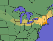
We're constructing animated maps of the major North American migrations. Take a look at the prototype Yankee migration map, showing where New England people settled. And check back often to see new maps of "people on the move."
WOULD YOU
LIKE TO LEARN MORE?
Migrations and culture areas are subjects of considerable interesting
debate today. Here is some background material you can read on the WWW:
- "What
are Cultural Landscapes?"
Institute of Cultural Landscape Studies, Harvard University Arnold Aroboretum
- Carl O. Sauer's "Foreword
to Historical Geography"
University of California, 1941 - "The South,
Where is it? What is it?"
by John Shelton Reed - The
Transformation of Hamilton County's Washington Township, 1830-1860
Cultural Migrations in Indiana from Conner Prairie - Regional
Lifeways
a presentation and critique of the Culture Area Concept from Chuck Smith, Cabrillo College - Migrations in
History
a world perspective from the Smithsonian Institution